

United States Maps
This collection contains United States maps owned by the Rod Library at the University of Northern Iowa.
To go to the Rod Library Maps home page, click here.
-

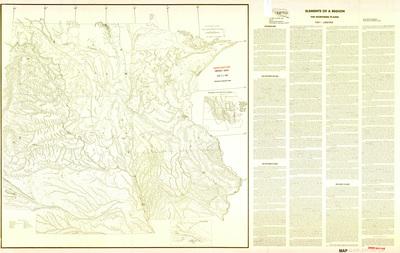
Elements of a region, the Northern Plains 1969 side 1
1969
Map of the Northern Plains region showing rivers, lakes, mountains, badlands, and other landforms. The right side has written information titled 'Elements of a Region'. Side one.
-

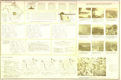
Elements of a region, the Northern Plains 1969 side 2
1969
Various expanded maps, aerial photographs, charts, and paragraphs of text relating to the Northern Plain region. Side two.
-

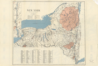
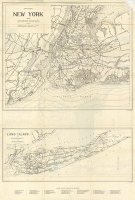
New York by NY State Historical Ass'n. 1940 side 1
1940
Map of New York showcasing cities, rivers, highways, historic sites, natural landmarks, and points of interest. Below the map is a list of points of interest. Side one.
-

New York by NY State Historical Ass'n. 1940 side 2
1940
Expanded city maps showcasing rivers, highways, historic sites, natural landmarks, and points of interest. Below the map is a list of points of interest. Side two.
-

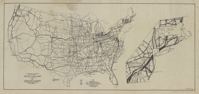
Traffic flow chart of the United States 1937
1937
Map of the United States featuring states, cities, and highways. The highways are sized relative to the amount of traffic they receive.
-
")
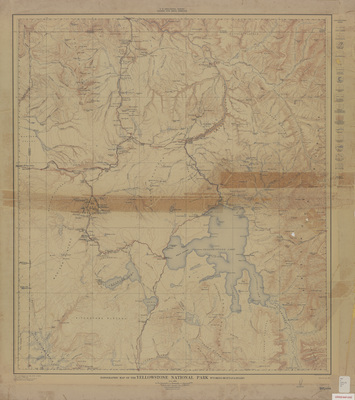
Topographic map of the Yellowstone Nat'l. Park 1912
1-1912
Topographic map of Yellowstone National Park showcasing roads, railroads, rivers, lakes, landmarks, and elevations. Water features marked in blue and elevations marked in red.
-

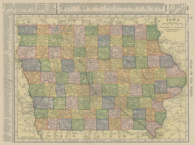
Iowa and Minnesota pages from Atlas of the World 1908
1908
Map of the state of Iowa showcasing counties, cities, rivers, and railroads. Different counties are highlighted different colors. To the top and left of the map is an index of Iowa counties and towns.
-

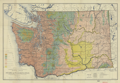
Floral areas of the State of Washington by Charles Piper 1906
1906
Map of the state of Washington showcasing counties, cities, rivers, and railroads. Different areas of the map are highlighted based on their floral area.
-

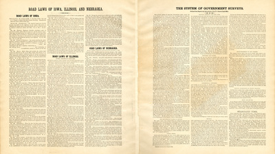
Map showing the principal meridians and base lines in the U.S. side 2
1895
On the left side, paragraphs of text explaining the "Road Laws of Iowa, Illinois, and Nebraska". To the right, paragraphs of text explaining "The System of Government Surveys".
-

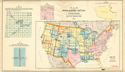
Map showing the principal meridians and base lines in the U.S. side 1
1895
Map of the United States featuring principle meridian lines highlighted in red showcasing different time zones. Different states and territories are highlighted different colors. To the left of the map are diagrams explaining how areas on a map are divided. Side one.
-

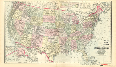
Gray's New Map of the United States 1874
1874
Map of the United States showcasing rivers, lakes, mountains, railroads, and cities of different populations. Different states are highlighted different colors.
-

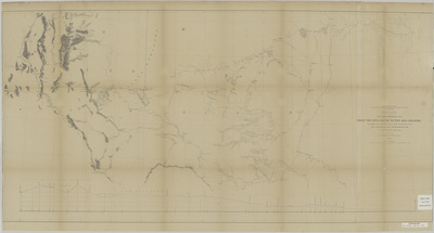
Explorations and surveys for a rail road route from the Mississippi River to the Pacific Ocean 1854-6 map and profile
1856
Map of the path from the Red River to the Rio Grande, showcasing rivers, lakes, elevations, and landmarks. Below the map is an elevation profile of the area.
-

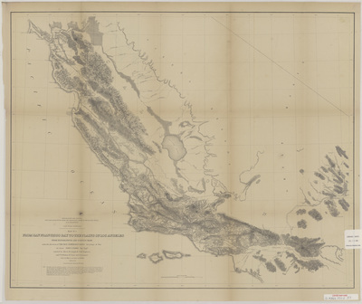
Explorations and surveys for a rail road route from the Mississippi River to the Pacific Ocean 1854-5 map 1
1855
Map of the path from San Francisco Bay to the Plains of Los Angeles, showcasing rivers, lakes, elevations, and landmarks. The solid black line marks potential railroad routes. Map one.
-

Explorations and surveys for a rail road route from the Mississippi River to the Pacific Ocean 1854-5 map 2
1855
Map of the path from the Pimas Village to Fort Fillmore, showcasing rivers, lakes, elevations, and landmarks. The solid black line marks potential railroad routes. Map two.
-

Explorations and surveys for a rail road route from the Mississippi River to the Pacific Ocean 1854-5 profiles
1855
Elevation profiles of the routes from San Francisco Bay to Los Angeles and from Pimas Villages to Fort Fillmore. Map three.
-

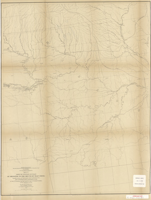
Explorations and surveys for a rail road route from the Mississippi River to the Pacific Ocean 1855 map 1
1855
Map of the path from Missouri to Trap Creek, showcasing rivers, lakes, towns, railroads, and landmarks. The double black lines mark potential railroad routes. Map one.
-

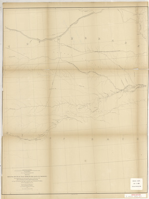
Explorations and surveys for a rail road route from the Mississippi River to the Pacific Ocean 1855 map 2
1855
Map of the path from Trap Creek to the Santa Fe crossing, showcasing rivers, lakes, elevations, and landmarks. The double black lines mark potential railroad routes. Map two.
-

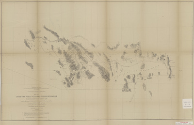
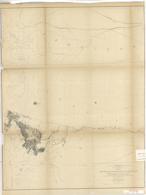
Explorations and surveys for a rail road route from the Mississippi River to the Pacific Ocean 1855 map 3
1855
Map of the path from the Santa Fe crossing to the Coo-Chie-To-Pa pass, showcasing rivers, lakes, elevations, and landmarks. The double black lines mark potential railroad routes. Map three.
-

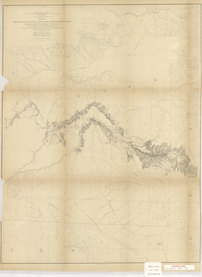
Explorations and surveys for a rail road route from the Mississippi River to the Pacific Ocean 1855 map 4
1855
Map of the path from the Coo-Chie-To-Pa pass to the Wahsatch Mountains, showcasing rivers, lakes, elevations, and landmarks. The double black lines mark potential railroad routes. Map four.
-

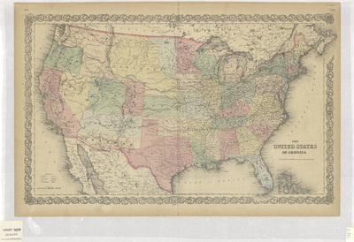
United States of America 1855 side 1
1855
Map of the United States showcasing rivers, lakes, mountains, railroads, State capitols, cities and towns. Different states and territories are highlighted different colors. Side one.
-

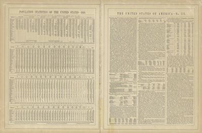
United States of America 1855 side 2
1855
Index of the population of the United States featured on the left, and general information about the United States on the right. Side two.
-

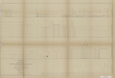
Explorations and surveys for a rail road route from the Mississippi River to the Pacific Ocean 1853-4 general profile
1854
General elevation profile of the area from Fort Smith Arkansas to Martinez near San Francisco California.
-

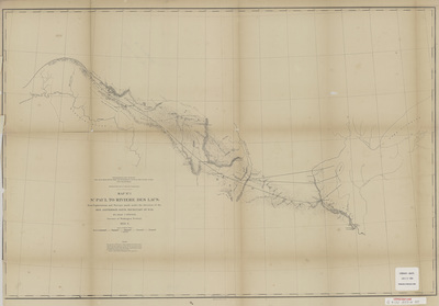
Explorations and surveys for a rail road route from the Mississippi River to the Pacific Ocean 1853-4 map 1
1854
Map of the path from St Paul to Riviere Des Lacs, showcasing rivers, lakes, elevations, and landmarks. The solid black line marks a potential railroad route. Map one.
-

Explorations and surveys for a rail road route from the Mississippi River to the Pacific Ocean 1853-4 map 2
1854
Map of the path from Riviere Des Lacs to the Rocky Mountains, showcasing rivers, lakes, elevations, and landmarks. The solid black line marks a potential railroad route. Map two.
-

Explorations and surveys for a rail road route from the Mississippi River to the Pacific Ocean 1853-4 map 3
1854
Map of the path from the Rocky Mountains to Puget Sound, showcasing rivers, lakes, elevations, and landmarks. The solid black line marks a potential railroad route. Map three.
-

Explorations and surveys for a rail road route from the Mississippi River to the Pacific Ocean 1853-4 map profiles
1854
Elevation profiles of routes near the 47th and 49th parallels.
-

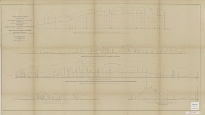
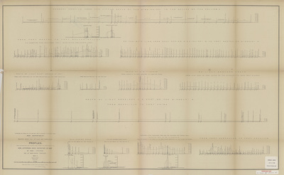
Explorations and surveys for a rail road route from the Mississippi River to the Pacific Ocean 1853 sheet 1
1853
Elevation profiles of mountain passes in the Sierra Nevada. Elevation profile charts for the Walker's, Hum-pah-ya-mup, Tah-ee-chay-pah, and San Fernando passes. Sheet one.
-

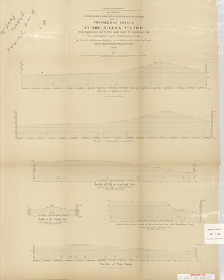
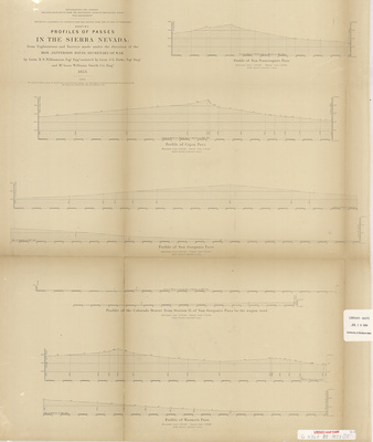
Explorations and surveys for a rail road route from the Mississippi River to the Pacific Ocean 1853 sheet 2
1853
Elevation profiles of mountain passes in the Sierra Nevada. Elevation profile charts for the San Francisquito, Cajon, San Gorgonio, and Warner's passes. Sheet two.
-

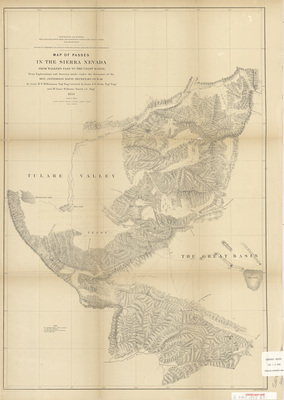
Explorations and surveys for a rail road route from the Mississippi River to the Pacific Ocean 1853 sheet 3
1853
Map of the passes in the Sierra Nevada showcasing elevations, rivers, and landmarks. Sheet three.
-

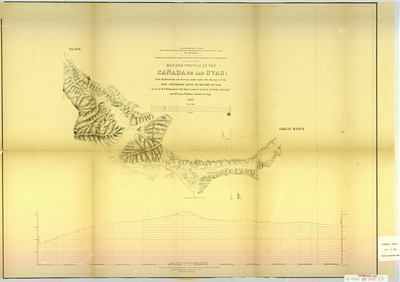
Map and profile of the Canada de las Uvas CA 1853
1853
Map of the Cañada de las Uvas showing rivers, elevations, and landmarks. Below the map is an elevation profile of the same area.
-

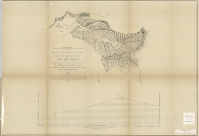
Map and profile of the Tejon Pass 1853
1853
Map of the Tejon Pass showing rivers, elevations, and landmarks. Below the map is an elevation profile of the pass.
-

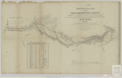
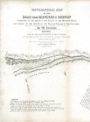
Topographical map of the road 1846 section 1
1846
Topographical map of the route from Missouri to Oregon, showcasing elevations, rivers, and natural landmarks. Section one. Below the map is a chart of 'Meteorological Observations' from the journey.
-

Topographical map of the road 1846 section 2
1846
Topographical map of the route from Missouri to Oregon, showcasing elevations, rivers, and natural landmarks. Section Two. Below the map is a list of 'Remarks' about the journey.
-

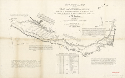
Topographical map of the road 1846 section 6
1846
Topographical map of the route from Missouri to Oregon, showcasing elevations, rivers, and natural landmarks. Section six. Below the map is a chart of 'Meteorological Observations', and around the map are excerpts related to the journey.
-

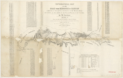
Topographical map of the road 1846 section 7
1846
Topographical map of the route from Missouri to Oregon, showcasing elevations, rivers, and natural landmarks. Section seven. Below the map is a chart of 'Meteorological Observations', and around the map are excerpts related to the journey.
-

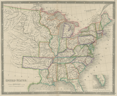
United States by Henry Teesdale 1843
1843
Map of the United States showcasing states, territories, cities, rivers, mountains, and railroads. Different states and territories are highlighted different colors.
-

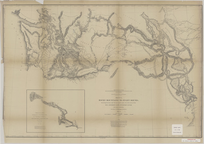
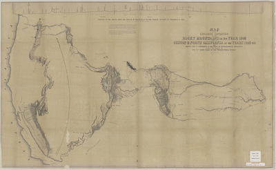
Map of an expedition to the Rocky Mts 1842 and to Oregon and N Calif 1843-44 by J C Fremont
1843
The Rocky Mountains and parts of Oregon and California mapped on an expedition from 1842-1844. Showcases elevations, rivers, and natural landmarks.
