Rod Library Maps
Continent
North America
Country
United States
Description
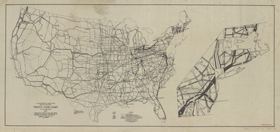
Map of the United States featuring states, cities, and highways. The highways are sized relative to the amount of traffic they receive.
Publication Date
1937
Publisher
United States Department of Agriculture, Bureau of Public Roads
Object Description
1 JPEG file
Rod Library Maps Subcollection
United States Maps
Physical Location
Special Collections & University Archives, Rod Library, University of Northern Iowa
Copyright
©1937 United States Department of Agriculture, Bureau of Public Roads
Document Type
Map
Language
en
File Format
image/jpeg
Recommended Citation
United States. Bureau of Public Roads, "Traffic flow chart of the United States 1937" (1937). Rod Library Maps. 605.
https://scholarworks.uni.edu/rodmaps/605
Preview