


Rod Library Maps
Continent
North America
Country
United States
Description
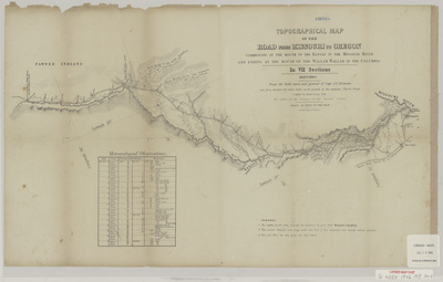
Topographical map of the route from Missouri to Oregon, showcasing elevations, rivers, and natural landmarks. Section one. Below the map is a chart of 'Meteorological Observations' from the journey.
Publication Date
1846
Publisher
E. Weber & Co.
City of Publication
Baltimore, MD
Object Description
1 JPEG file
Scale - Original
1:633,600
Rod Library Maps Subcollection
United States Maps
Physical Location
Special Collections & University Archives, Rod Library, University of Northern Iowa
Copyright
©1846
Document Type
Map
Language
en
File Format
image/jpeg
Recommended Citation
"Topographical map of the road 1846 section 1" (1846). Rod Library Maps. 607.
https://scholarworks.uni.edu/rodmaps/607
Preview

Comments
This is a part of a multi-image map. Click the links below to view the other parts:
Topographical map of the road 1846 section 2
Topographical map of the road 1846 section 6
Topographical map of the road 1846 section 7