Rod Library Maps
Continent
North America
Country
United States
Description
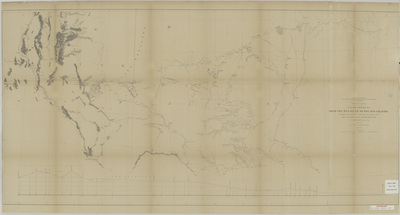
Map of the path from the Red River to the Rio Grande, showcasing rivers, lakes, elevations, and landmarks. Below the map is an elevation profile of the area.
Publication Date
1856
Object Description
1 JPEG file
Scale - Original
1:950,400
Rod Library Maps Subcollection
United States Maps
Physical Location
Special Collections & University Archives, Rod Library, University of Northern Iowa
Copyright
©1856
Document Type
Map
Language
en
File Format
image/jpeg
Recommended Citation
"Explorations and surveys for a rail road route from the Mississippi River to the Pacific Ocean 1854-6 map and profile" (1856). Rod Library Maps. 626.
https://scholarworks.uni.edu/rodmaps/626
Preview