Rod Library Maps
Continent
North America
Country
United States
Description
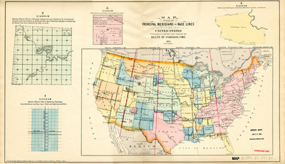
Map of the United States featuring principle meridian lines highlighted in red showcasing different time zones. Different states and territories are highlighted different colors. To the left of the map are diagrams explaining how areas on a map are divided. Side one.
Publication Date
1895
Object Description
1 JPEG file
Rod Library Maps Subcollection
United States Maps
Physical Location
Special Collections & University Archives, Rod Library, University of Northern Iowa
Copyright
©1895
Document Type
Map
Language
en
File Format
image/jpeg
Recommended Citation
Dunham, J. R., "Map showing the principal meridians and base lines in the U.S. side 1" (1895). Rod Library Maps. 614.
https://scholarworks.uni.edu/rodmaps/614
Preview