Rod Library Maps
Continent
North America
Country
United States
State/Province
California
Description
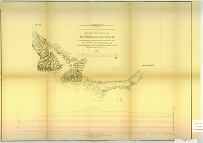
Map of the Cañada de las Uvas showing rivers, elevations, and landmarks. Below the map is an elevation profile of the same area.
Publication Date
1853
Object Description
1 JPEG file
Scale - Original
1:60,000 & 1:12,000
Rod Library Maps Subcollection
United States Maps
Physical Location
Special Collections & University Archives, Rod Library, University of Northern Iowa
Copyright
©1853
Document Type
Map
Language
en
File Format
image/jpeg
Recommended Citation
"Map and profile of the Canada de las Uvas CA 1853" (1853). Rod Library Maps. 616.
https://scholarworks.uni.edu/rodmaps/616
Preview