Rod Library Maps
Description
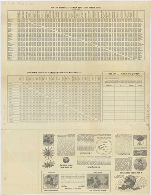
Milage charts for air travel and steamship travel on the top of the page. Paragraphs of information regarding air travel on the bottom of the page. Side two.
Publication Date
1943
Publisher
Rand McNally & Company
City of Publication
Chicago, Ill.
Object Description
1 JPEG file
Rod Library Maps Subcollection
World Maps
Physical Location
Special Collections & University Archives, Rod Library, University of Northern Iowa
Copyright
©1946 Rand McNally & Company
Document Type
Map
Language
en
File Format
image/jpeg
Recommended Citation
Rand McNally & Company, "Rand McNally polar map of the world 1943 side 2" (1943). Rod Library Maps. 427.
https://scholarworks.uni.edu/rodmaps/427
Preview