Rod Library Maps
Continent
North America
Country
United States
State/Province
Iowa
Description
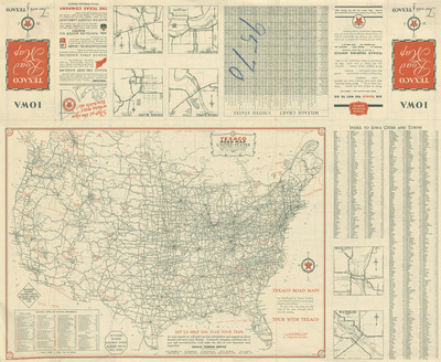
Map of the United States showcasing cities and highways, and an index to Iowa cities and towns on the bottom. On the top is the map cover, expanded city road maps, and a mileage chart. Side two.
Publication Date
1936
Publisher
Rand McNally & Co.
City of Publication
Chicago, Ill.
Object Description
1 JPEG file
Scale - Original
1:9,377,280
Rod Library Maps Subcollection
Iowa Maps
Physical Location
Special Collections & University Archives, Rod Library, University of Northern Iowa
Copyright
©1936 Rand McNally & Co.
Document Type
Map
Language
en
File Format
image/jpeg
Recommended Citation
Rand McNally & Co. and Texaco, "Texaco road map Iowa 1936 side 2" (1936). Rod Library Maps. 844.
https://scholarworks.uni.edu/rodmaps/844
Preview