Rod Library Maps
Continent
North America
Country
United States
State/Province
Iowa
Description
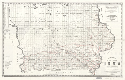
Map of the state of Iowa showcasing counties, townships, and rivers. Roads and railroads are also featured in red. Side one.
Publication Date
1851
Publisher
R.L. Barnes
City of Publication
Philadelphia, Penn.
Object Description
1 JPEG file
Rod Library Maps Subcollection
Iowa Maps
Physical Location
Special Collections & University Archives, Rod Library, University of Northern Iowa
Copyright
©1851 R.L. Barnes
Document Type
Map
Language
en
File Format
image/jpeg
Recommended Citation
Henn, Williams & Co., "Township map of the State of Iowa 1851 side 1" (1851). Rod Library Maps. 843.
https://scholarworks.uni.edu/rodmaps/843
Preview