Rod Library Maps
Continent
North America
Country
United States
State/Province
Iowa
Description
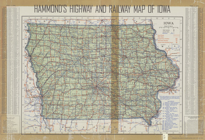
Map of the state of Iowa showcasing counties, cities, rivers, landmarks, roads, and railroads. Roads are marked in red, railroads are marked in blue. To the left of the map is an index of counties, cities, and towns.
Publication Date
1947
Publisher
Benjamin Hilfman
Object Description
1 JPEG file
Rod Library Maps Subcollection
Iowa Maps
Physical Location
Special Collections & University Archives, Rod Library, University of Northern Iowa
Copyright
©1947 C.S. Hammond & Co.
Document Type
Map
Language
en
File Format
image/jpeg
Recommended Citation
C.S. Hammond & Co,, "Hammonds highway and railway map of Iowa 1947" (1947). Rod Library Maps. 815.
https://scholarworks.uni.edu/rodmaps/815
Preview