Rod Library Maps
Continent
North America
Country
United States
State/Province
Iowa
Description
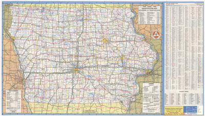
Map of the state of Iowa showcasing counties, cities, rivers, highways, and roads. Population index of cities and villages in Iowa to the right of the map. Side one.
Publication Date
1979
Publisher
Cartech, Inc.
Object Description
1 JPEG file
Scale - Original
1:823,680
Rod Library Maps Subcollection
Iowa Maps
Physical Location
Special Collections & University Archives, Rod Library, University of Northern Iowa
Copyright
©1979 Iowa Department of Transportation
Document Type
Map
Language
en
File Format
image/jpeg
Recommended Citation
"Iowa transportation map 1979-1980 side 1" (1979). Rod Library Maps. 730.
https://scholarworks.uni.edu/rodmaps/730
Preview