Rod Library Maps
Continent
North America
Country
United States
State/Province
Iowa
Description
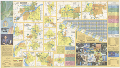
Includes the cover image for the 'Iowa Official State Transportation Map', along with a milepost chart, an index of state parks and recreation areas, and several expanded city maps of larger Iowa cities. There is a collage of images related to Iowa attractions. Side two of map.
Publication Date
1981
Object Description
1 JPEG file
Rod Library Maps Subcollection
Iowa Maps
Physical Location
Special Collections & University Archives, Rod Library, University of Northern Iowa
Copyright
©1981 Iowa Department of Transportation
Document Type
Map
Language
en
File Format
image/jpeg
Recommended Citation
"Iowa transportation map 1981-1982 side 2" (1981). Rod Library Maps. 727.
https://scholarworks.uni.edu/rodmaps/727
Preview