Rod Library Maps
Keywords
Topographic maps--United States;
Continent
North America
Country
United States
State/Province
Iowa
County
Cedar
Description
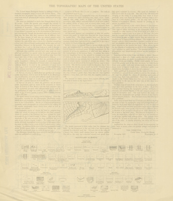
An essay on the topographic mapping being done by the United States Geological Survey. A legend of standard symbols is at the bottom of the page. Side two.
Publication Date
1901
Publisher
United States Geological Survey
City of Publication
Denver, Colorado
Object Description
1 JPEG file
Rod Library Maps Subcollection
Iowa Maps
Physical Location
Special Collections & University Archives, Rod Library, University of Northern Iowa
Copyright
©1901 U.S. Geological Survey
Document Type
Map
Language
en
File Format
image/jpeg
Recommended Citation
Geological Survey (U.S.), "Stanwood Quadrangle by USGS 1901 side 2" (1901). Rod Library Maps. 93.
https://scholarworks.uni.edu/rodmaps/93
Preview