Rod Library Maps
Continent
North America
Country
United States
State/Province
Iowa
Description
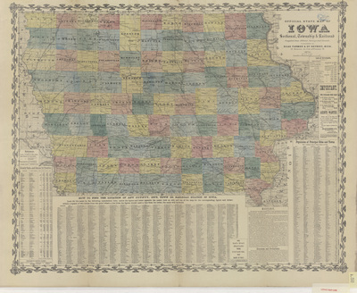
Map of the state of Iowa showcasing counties, townships, cities, rivers, and railroads. Surrounding the map are several indexes: population by county; county, city, town, railroad station location; population by cities; and other historical Iowa information. Side one.
Publication Date
1873
Publisher
Silas Farmer & Co.
Object Description
1 JPEG file
Scale - Original
1:760,320
Rod Library Maps Subcollection
Iowa Maps
Physical Location
Special Collections & University Archives, Rod Library, University of Northern Iowa
Copyright
©1873 Silas Farmer and ©1871 G.W. & C.B. Colton & Co
Document Type
Map
Language
en
File Format
image/jpeg
Recommended Citation
Silas Farmer & Co. and G.W. & C.B. Colton & Co., "Official state map of Iowa 1873 side 1" (1873). Rod Library Maps. 869.
https://scholarworks.uni.edu/rodmaps/869
Preview