Rod Library Maps
Continent
North America
Country
United States
State/Province
Iowa
Description
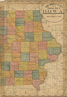
Map of the state of Iowa, eastern half, showcasing counties, townships, cities, rivers, and railroads. Different counties highlighted different colors. Sheet two.
Publication Date
1884
Publisher
Rand McNally & Co.
City of Publication
Chicago, Ill.
Object Description
1 JPEG file
Scale - Original
1:506,880
Rod Library Maps Subcollection
Iowa Maps
Physical Location
Special Collections & University Archives, Rod Library, University of Northern Iowa
Copyright
©1884 Rand McNally & Co.
Document Type
Map
Language
en
File Format
image/jpeg
Recommended Citation
Rand McNally & Co., "Rand McNally's new sectional map of Iowa part 2" (1884). Rod Library Maps. 862.
https://scholarworks.uni.edu/rodmaps/862
Preview