


Rod Library Maps
Continent
North America
Country
United States
State/Province
Iowa
County
Polk
City
Des Moines
Description
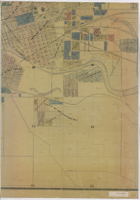
Map of Des Moines showcasing rivers, railroads, streets, plats, buildings, wards, and various landmarks. Different subdivisions highlighted different colors. Sheet 7.
Publication Date
1893
Publisher
Western Lithographing Co.
City of Publication
Des Moines, Iowa
Object Description
1 JPEG file
Rod Library Maps Subcollection
Iowa Maps
Physical Location
Special Collections & University Archives, Rod Library, University of Northern Iowa
Document Type
Map
Language
en
File Format
image/jpeg
Recommended Citation
Schreiner, B., "Schreiner's map of Des Moines 1893 sheet 7" (1893). Rod Library Maps. 853.
https://scholarworks.uni.edu/rodmaps/853
Preview

Comments
This is a part of a multi-image map. Click the links below to view the other parts:
Schreiner's map of Des Moines 1893 sheet 1
Schreiner's map of Des Moines 1893 sheet 2
Schreiner's map of Des Moines 1893 sheet 3
Schreiner's map of Des Moines 1893 sheet 4
Schreiner's map of Des Moines 1893 sheet 5
Schreiner's map of Des Moines 1893 sheet 6
Schreiner's map of Des Moines 1893 sheet 8