Rod Library Maps
Continent
North America
Country
United States
State/Province
Iowa
Description
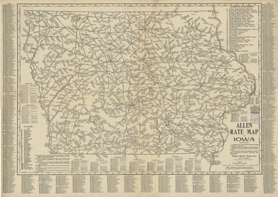
Map of the state of Iowa showcasing railroads and shipping routes, with codes showing shipping rates marked at various cities. Surrounding the map of indexes of towns in Iowa and various rate charts.
Publication Date
1902
Publisher
Allen Rate Map Co.
Object Description
1 JPEG file
Scale - Original
1:823,680
Rod Library Maps Subcollection
Iowa Maps
Physical Location
Special Collections & University Archives, Rod Library, University of Northern Iowa
Copyright
©1902 Allen Rate Map Co.
Document Type
Map
Language
en
File Format
image/jpeg
Recommended Citation
Allen Rate Map Co., "Allen rate map of Iowa" (1902). Rod Library Maps. 839.
https://scholarworks.uni.edu/rodmaps/839
Preview