Rod Library Maps
Continent
North America
Country
United States
State/Province
Iowa
County
Pottawattamie
City
Council Bluffs
Description
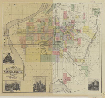
Map of Council Bluffs showcasing rivers, railroads, streets, plats, buildings, wards, and various landmarks. Different subdivisions highlighted different colors. Illustrations of various Council Bluff buildings below the map.
Publication Date
1890
Publisher
C.R. Allen
Object Description
1 JPEG file
Rod Library Maps Subcollection
Iowa Maps
Physical Location
Special Collections & University Archives, Rod Library, University of Northern Iowa
Copyright
©1890 C.R. Allen
Document Type
Map
Language
en
File Format
image/jpeg
Recommended Citation
Allen, C. R., "Allen's suburban map of Council Bluffs 1890" (1890). Rod Library Maps. 838.
https://scholarworks.uni.edu/rodmaps/838
Preview