Rod Library Maps
Continent
North America
Country
United States
State/Province
Iowa
Description
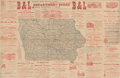
Map of the state of Iowa featuring counties, cities, railroads, and rivers, with red concentric lines overlaid on the map ten miles apart and centered on Des Moines. Around the map are a variety of ads for businesses, some with illustrations.
Publication Date
1887
Object Description
1 JPEG file
Rod Library Maps Subcollection
Iowa Maps
Physical Location
Special Collections & University Archives, Rod Library, University of Northern Iowa
Copyright
©1887 Carey
Document Type
Map
Language
en
File Format
image/jpeg
Recommended Citation
Carey, "Carey's radius map and shippers guide" (1887). Rod Library Maps. 834.
https://scholarworks.uni.edu/rodmaps/834
Preview