Rod Library Maps
Continent
North America
Country
United States
State/Province
Iowa
Description
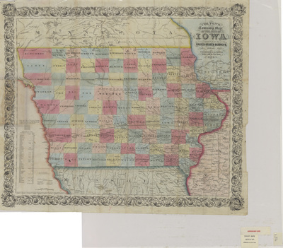
Map of the state of Iowa showcasing counties, townships, rivers, railroads, and roads. To the left of the map is an index of the population of Iowa.
Publication Date
1853
Publisher
J.H. Colton
City of Publication
New York, NY
Object Description
1 JPEG file
Rod Library Maps Subcollection
Iowa Maps
Physical Location
Special Collections & University Archives, Rod Library, University of Northern Iowa
Copyright
©1851 J.H. Colton
Document Type
Map
Language
en
File Format
image/jpeg
Recommended Citation
Colton, J. H. and Colton, Geo. W., "Coltons township map of the State of Iowa 1853" (1853). Rod Library Maps. 825.
https://scholarworks.uni.edu/rodmaps/825
Preview