Rod Library Maps
Continent
North America
Country
United States
State/Province
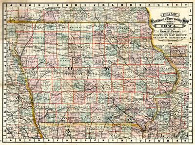
Iowa
Description
Map of the state of Iowa showcasing counties, cities, rivers, and railroads. Counties are highlighted different colors and outlined in red.
Publication Date
1879
Publisher
Geo. F. Cram
City of Publication
Chicago, Ill.
Object Description
1 JPEG file
Scale - Original
1:1,203,840
Rod Library Maps Subcollection
Iowa Maps
Physical Location
Special Collections & University Archives, Rod Library, University of Northern Iowa
Copyright
©1878 G.F. Cram
Document Type
Map
Language
en
File Format
image/jpeg
Recommended Citation
Cram, Geo. F., "Cram's Rail Road & Township Map of Iowa" (1879). Rod Library Maps. 824.
https://scholarworks.uni.edu/rodmaps/824
Preview