Rod Library Maps
Continent
North America
Country
United States
State/Province
Iowa
Description
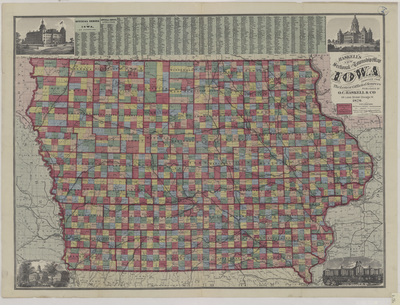
Map of the state of Iowa showcasing counties, townships, cities, rivers, and railroads. Different townships are highlighted different colors with counties outlined in red. Small illustrations related to Iowa in the four corners.
Publication Date
1876
Publisher
O.C. Haskell & Co.
City of Publication
Chicago, Ill.
Object Description
1 JPEG file
Scale - Original
1:633,600
Rod Library Maps Subcollection
Iowa Maps
Physical Location
Special Collections & University Archives, Rod Library, University of Northern Iowa
Copyright
©1875 Gaylord Watson
Document Type
Map
Language
en
File Format
image/jpeg
Recommended Citation
O.C. Haskell & Co., "Haskells new sectional and township map of Iowa 1876" (1876). Rod Library Maps. 814.
https://scholarworks.uni.edu/rodmaps/814
Preview