Rod Library Maps
Continent
North America
Country
United States
State/Province
Iowa
Description
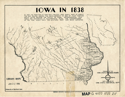
Map of the territory of Iowa, showcasing the surveyed eastern part and the unsurveyed western part. Features townships, purchase lines, select landmarks, and rivers.
Object Description
1 JPEG file
Rod Library Maps Subcollection
Iowa Maps
Physical Location
Special Collections & University Archives, Rod Library, University of Northern Iowa
Copyright
©Iowa State Planning Board
Document Type
Map
Language
en
File Format
image/jpeg
Recommended Citation
Iowa State Planning Board and Iowa State Historical Department, "Iowa in 1838" (2019). Rod Library Maps. 801.
https://scholarworks.uni.edu/rodmaps/801
Preview