Rod Library Maps
Continent
North America
Country
United States
State/Province
Iowa
Description
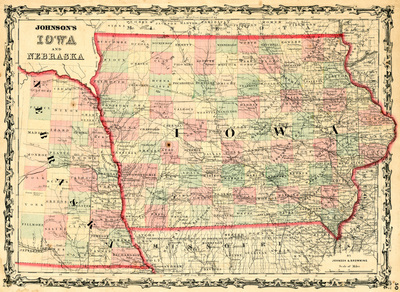
Map of Iowa and part of Nebraska featuring counties, cities, railroads, and rivers. Different counties are highlighted different colors and the states are outlined in red.
Publication Date
1861
Object Description
1 JPEG file
Rod Library Maps Subcollection
Iowa Maps
Physical Location
Special Collections & University Archives, Rod Library, University of Northern Iowa
Copyright
©1861 Johnson & Browning
Document Type
Map
Language
en
File Format
image/jpeg
Recommended Citation
Johnson & Browning, "Johnson's Iowa & Nebraska 1861" (1861). Rod Library Maps. 791.
https://scholarworks.uni.edu/rodmaps/791
Preview