Rod Library Maps
Continent
North America
Country
United States
State/Province
Iowa
County
Scott
City
Davenport
Description
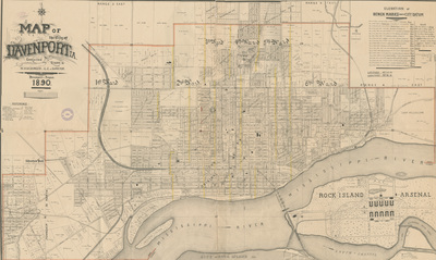
Map of Davenport showcasing rivers, railroads, streets, plats, buildings, wards, and various landmarks. City limits outlined in red. To the right of the map is a list of elevations of benchmarks.
Publication Date
1890
Object Description
1 JPEG file
Rod Library Maps Subcollection
Iowa Maps
Physical Location
Special Collections & University Archives, Rod Library, University of Northern Iowa
Copyright
©1890 M. Huebinger
Document Type
Map
Language
en
File Format
image/jpeg
Recommended Citation
Huebinger, M., "Map of the City of Davenport 1890" (1890). Rod Library Maps. 778.
https://scholarworks.uni.edu/rodmaps/778
Preview