Rod Library Maps
Continent
North America
Country
United States
State/Province
Iowa
Description
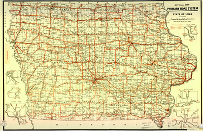
Map of the state of Iowa showcasing counties, cities, rivers, railroads, and major roadways. Major roadways are highlighted in red. Several expanded city road maps surround the main map.
Publication Date
1926
Publisher
Iowa State Highway Commission
City of Publication
Ames, Iowa?
Object Description
1 JPEG file
Scale - Original
1:633,600
Rod Library Maps Subcollection
Iowa Maps
Physical Location
Special Collections & University Archives, Rod Library, University of Northern Iowa
Copyright
©1926 Iowa State Highway Commission
Document Type
Map
Language
en
File Format
image/jpeg
Recommended Citation
Iowa State Highway Commission, "Official map primary road system 1926" (1926). Rod Library Maps. 769.
https://scholarworks.uni.edu/rodmaps/769
Preview