Rod Library Maps
Continent
North America
Country
United States
State/Province
Iowa
County
Black Hawk
City
Cedar Falls
Description
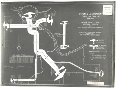
Map of the major roads in Cedar Falls showing how much origin, destination, and through traffic they receive. The roads are sized relative to the amount of traffic they receive. Background of the map is gray and the ink is white.
Publication Date
1937
Object Description
1 JPEG file
Rod Library Maps Subcollection
Iowa Maps
Physical Location
Special Collections & University Archives, Rod Library, University of Northern Iowa
Copyright
©1937 Iowa State Planning Board
Document Type
Map
Language
en
File Format
image/jpeg
Recommended Citation
Iowa State Planning Board, "Origin & destination through traffic Cedar Falls 1937" (1937). Rod Library Maps. 768.
https://scholarworks.uni.edu/rodmaps/768
Preview