Rod Library Maps
Continent
North America
Country
United States
State/Province
Iowa
Description
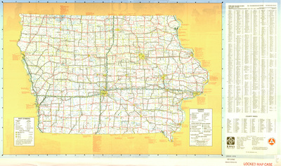
Transportation map of the state of Iowa showing highways; access points and route markers; mileages; air, rail and water markers; recreation areas; and safety rest areas. To the right of the map is an index of cities, villages, and counties. Side one of map.
Publication Date
1982
Object Description
1 JPEG file
Scale - Original
1:823,680
Rod Library Maps Subcollection
Iowa Maps
Physical Location
Special Collections & University Archives, Rod Library, University of Northern Iowa
Copyright
©1982 Iowa Department of Transportation
Document Type
Map
Language
en
File Format
image/jpeg
Recommended Citation
"Iowa transportation map 1982 side 1" (1982). Rod Library Maps. 726.
https://scholarworks.uni.edu/rodmaps/726
Preview