Rod Library Maps
Continent
North America
Country
United States
State/Province
Iowa
Description
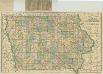
Map of the state of Iowa showcasing counties, cities, rivers, and railroads. Different counties are highlighted different colors. To the top of the map is a small attached sheet of 'Explanatory' text. Side one.
Publication Date
1895
Publisher
The Matthews-Northrup Co.
Object Description
1 JPEG file
Scale - Original
1:1,203,840
Rod Library Maps Subcollection
Iowa Maps
Physical Location
Special Collections & University Archives, Rod Library, University of Northern Iowa
Copyright
©1895 The Matthew-Northrup Co.
Document Type
Map
Language
en
File Format
image/jpeg
Recommended Citation
The Matthew-Northrup Co., "Iowa by Matthews-Northrup side 1" (1895). Rod Library Maps. 680.
https://scholarworks.uni.edu/rodmaps/680
Preview