Rod Library Maps
Continent
North America
Country
United States
State/Province
Iowa
Description
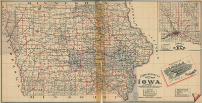
Map of the state of Iowa showcasing counties, cities, rivers, roads, and railroads. Main touring routes are outlined in red. In the top right, an expanded road map of Polk county. Side one.
Publication Date
1902
Publisher
C.S. Mendenhall
Object Description
1 JPEG file
Rod Library Maps Subcollection
Iowa Maps
Physical Location
Special Collections & University Archives, Rod Library, University of Northern Iowa
Copyright
©1902 C.S. Mendenhall
Document Type
Map
Language
en
File Format
image/jpeg
Recommended Citation
Mendenhall, C. S., "Mendenhalls road map of Iowa side 1" (1902). Rod Library Maps. 678.
https://scholarworks.uni.edu/rodmaps/678
Preview