


Rod Library Maps
Continent
North America
Country
United States
State/Province
Iowa
Description
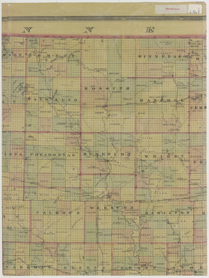
Part of a map of the state of Iowa showcasing counties, townships, cities, rivers, and railroads. Different townships are highlighted different colors. Sheet two.
Publication Date
1873
Publisher
Mills and Co.
City of Publication
Des Moines, Iowa
Object Description
1 JPEG file
Scale - Original
1:253,440
Rod Library Maps Subcollection
Iowa Maps
Physical Location
Special Collections & University Archives, Rod Library, University of Northern Iowa
Copyright
©1873 Mills and Co
Document Type
Map
Language
en
File Format
image/jpeg
Recommended Citation
Thornton, A. L. and Walling, H. F., "Mills & Co. map Iowa 1873 sheet 2" (1873). Rod Library Maps. 675.
https://scholarworks.uni.edu/rodmaps/675
Preview

Comments
This is a part of a multi-image map. Click the links below to view the other parts:
Mills & Co. map Iowa 1873 sheet 1
Mills & Co. map Iowa 1873 sheet 3
Mills & Co. map Iowa 1873 sheet 4
Mills & Co. map Iowa 1873 sheet 5
Mills & Co. map Iowa 1873 sheet 6
Mills & Co. map Iowa 1873 sheet 7
Mills & Co. map Iowa 1873 sheet 8