Rod Library Maps
Continent
North America
Country
United States
State/Province
Iowa
Description
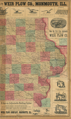
Map of the state of Iowa, eastern half, showcasing counties, townships, cities, rivers, and railroads. Different counties highlighted different colors. Map surrounded by illustrated ads for farm equipment. Sheet two.
Publication Date
1878
Publisher
Weir Plow Co.
Object Description
1 JPEG file
Rod Library Maps Subcollection
Iowa Maps
Physical Location
Special Collections & University Archives, Rod Library, University of Northern Iowa
Copyright
©1878 Henry S. Stebbins
Document Type
Map
Language
en
File Format
image/jpeg
Recommended Citation
Stebbins, Henry S. and Weir Plow Co., "New sectional map of Iowa part 2" (1878). Rod Library Maps. 659.
https://scholarworks.uni.edu/rodmaps/659
Preview