Rod Library Maps
Continent
North America
Country
United States
State/Province
Iowa
Description
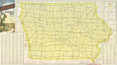
Map of the state of Iowa showcasing counties, cities, rivers, highways, and roads. To the left of the map is the cover image. Below the map is a population index of cities and villages in Iowa. Side one.
Publication Date
1953
Publisher
Johnson Printing Inc.
Object Description
1 JPEG file
Rod Library Maps Subcollection
Iowa Maps
Physical Location
Special Collections & University Archives, Rod Library, University of Northern Iowa
Copyright
©1953 Iowa State Highway Commission
Document Type
Map
Language
en
File Format
image/jpeg
Recommended Citation
Iowa State Highway Commission and Rand McNally & Company, "Official highway map of Iowa 1953 side 1" (1953). Rod Library Maps. 650.
https://scholarworks.uni.edu/rodmaps/650
Preview