Rod Library Maps
Continent
North America
Country
United States
State/Province
Iowa
Description
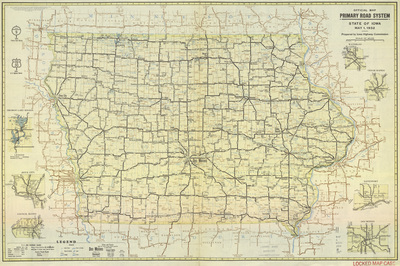
Map of the state of Iowa showcasing counties, cities, rivers, highways, and roads. Surrounding the map are expanded city road maps. Side one.
Publication Date
1932
Publisher
American Lithographing and Printing Co.
City of Publication
Des Moines, Iowa
Object Description
1 JPEG file
Rod Library Maps Subcollection
Iowa Maps
Physical Location
Special Collections & University Archives, Rod Library, University of Northern Iowa
Copyright
©1932 American Lithographing and Printing Co.
Document Type
Map
Language
en
File Format
image/jpeg
Recommended Citation
Iowa State Highway Commission, "Official map primary road system 1932 side 1" (1932). Rod Library Maps. 634.
https://scholarworks.uni.edu/rodmaps/634
Preview