


Rod Library Maps
Continent
North America
Country
United States
State/Province
Iowa
Description
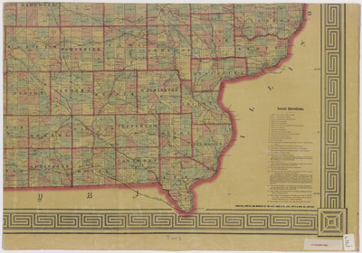
Part of a map of the state of Iowa showcasing counties, townships, cities, rivers, roads, railroads, and natural landmarks. Different townships are highlighted different colors. Sheet four.
Publication Date
1870
Object Description
1 JPEG file
Scale - Original
1:380,160
Rod Library Maps Subcollection
Iowa Maps
Physical Location
Special Collections & University Archives, Rod Library, University of Northern Iowa
Copyright
©1870 Asher & Adams
Document Type
Map
Language
en
File Format
image/jpeg
Recommended Citation
Asher & Adams, "Asher & Adams civil & congressional township map Iowa 1870 sheet 4" (1870). Rod Library Maps. 596.
https://scholarworks.uni.edu/rodmaps/596
Preview

Comments
This is a part of a multi-image map. Click the links below to view the other parts:
Asher & Adams civil & congressional township map Iowa 1870 sheet 1
Asher & Adams civil & congressional township map Iowa 1870 sheet 2
Asher & Adams civil & congressional township map Iowa 1870 sheet 3