Rod Library Maps
Continent
North America
Country
United States
State/Province
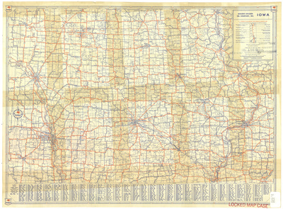
Iowa
Description
Map of the state of Iowa showcasing counties, cities, rivers, highways, and roads. Interstate highways are marked in red. Below the map is an index of towns in Iowa. Side one.
Publication Date
1947
Publisher
Rand McNally and Company
City of Publication
Chicago, Ill.
Object Description
1 JPEG file
Rod Library Maps Subcollection
Iowa Maps
Physical Location
Special Collections & University Archives, Rod Library, University of Northern Iowa
Copyright
©1947 Rand McNally & Company
Document Type
Map
Language
en
File Format
image/jpeg
Recommended Citation
Rand McNally & Company and Socony-Vacuum Oil Company Inc., "Iowa by Socony-Vacuum Oil Co. 1947 side 1" (1947). Rod Library Maps. 560.
https://scholarworks.uni.edu/rodmaps/560
Preview