Rod Library Maps
Description
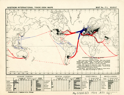
Map of the world showing lines of import in blue, lines of export in red, and regions of productions. Below the map are charts comparing exporting and importing counties.
Publication Date
1924
Publisher
A.J. Nystrom & Co.
City of Publication
Chicago, Ill.
Object Description
1 JPEG file
Rod Library Maps Subcollection
World Maps
Physical Location
Special Collections & University Archives, Rod Library, University of Northern Iowa
Copyright
©1924 S.J. Roper
Document Type
Map
Language
en
File Format
image/jpeg
Recommended Citation
Roper, S. J., "Nystrom international trade desk map wheat 1924" (1924). Rod Library Maps. 417.
https://scholarworks.uni.edu/rodmaps/417
Preview