Rod Library Maps
Continent
North America
Country
United States
State/Province
Iowa
County
Polk
Description
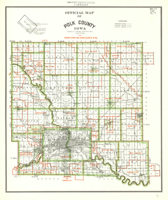
Map of Polk County with townships seperated by green lines, and school and taxing districts seperated by red lines. Map also shows cities, rivers, roads, railroads, and other landmarks.
Publication Date
1955
Publisher
American Lithographing and Printing Co.
City of Publication
Des Moines, Iowa
Object Description
1 JPEG file
Rod Library Maps Subcollection
Iowa Maps
Physical Location
Special Collections & University Archives, Rod Library, University of Northern Iowa
Copyright
©1955 American Lithographing and Printing Co.
Document Type
Map
Language
en
File Format
image/jpeg
Recommended Citation
American Lithographing and Printing Company, "Official Map of Polk County 1955" (1955). Rod Library Maps. 388.
https://scholarworks.uni.edu/rodmaps/388
Preview