Rod Library Maps
Continent
North America
Country
United States
State/Province
Iowa
County
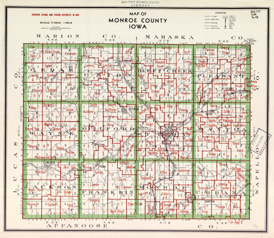
Monroe
Description
Monroe County, Iowa with townships outlined in green and school and taxing districts outlined in red. Legend includes U.S. Roads, Primary Roads, Trunk Roads, Local Roads, Drainage Ditches, Steam RRs, Electric RRs, District Schools, Churches, Cemeteries, Gravel Pits, Mines, and Quarries.
Publisher
American Lithographing and Printing Co.
City of Publication
Des Moines, Iowa
Object Description
1 JPEG file
Scale - Original
1:84,480
Rod Library Maps Subcollection
Iowa Maps
Physical Location
Special Collections & University Archives, Rod Library, University of Northern Iowa
Copyright
©American Lithographing and Printing Co.
Document Type
Map
Language
en
File Format
image/jpeg
Recommended Citation
American Lithographing and Printing Company, "Map of Monroe County Iowa" (2019). Rod Library Maps. 324.
https://scholarworks.uni.edu/rodmaps/324
Preview