Rod Library Maps
Keywords
Black Hawk County (Iowa)--Maps;
Continent
North America
Country
United States
State/Province
Iowa
County
Black Hawk
Description
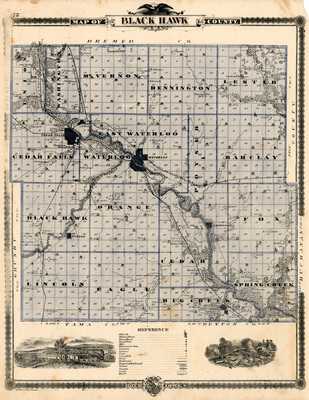
Black Hawk County, with townships separated by blue lines, and depicting churches, schools, farms, cemeteries, roads, railroads, and other features via illustrations. The map was taken from the A.T. Andreas' Illustrated historical atlas of the state of Iowa published by Chas. Shober & Co., Chicago Lith. Co.
Publication Date
1875
Publisher
Chas. Shober & Co., Chicago Lith. Co.
City of Publication
Chicago, Ill.
Object Description
1 JPEG file
Rod Library Maps Subcollection
Iowa Maps
Physical Location
Special Collections & University Archives, Rod Library, University of Northern Iowa
Copyright
©1875 Chas. Shober & Co., Chicago Lith. Co.
Document Type
Map
Language
en
File Format
image/jpeg
Recommended Citation
Andreas, A. T. (Alfred Theodore), "Map of Black Hawk County 1875" (1875). Rod Library Maps. 31.
https://scholarworks.uni.edu/rodmaps/31
Preview