


Rod Library Maps
Continent
North America
Country
United States
Description
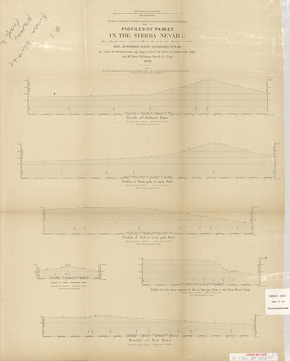
Elevation profiles of mountain passes in the Sierra Nevada. Elevation profile charts for the Walker's, Hum-pah-ya-mup, Tah-ee-chay-pah, and San Fernando passes. Sheet one.
Publication Date
1853
Object Description
1 JPEG file
Scale - Original
1:120,000 & 1:24,000
Rod Library Maps Subcollection
United States Maps
Physical Location
Special Collections & University Archives, Rod Library, University of Northern Iowa
Copyright
©1853
Document Type
Map
Language
en
File Format
image/jpeg
Recommended Citation
"Explorations and surveys for a rail road route from the Mississippi River to the Pacific Ocean 1853 sheet 1" (1853). Rod Library Maps. 401.
https://scholarworks.uni.edu/rodmaps/401
Preview

Comments
This is a part of a multi-image map. Click the links below to view the other parts:
Explorations and surveys for a rail road route 1853 sheet 2
Explorations and surveys for a rail road route 1853 sheet 3