


Rod Library Maps
Keywords
Black Hawk County (Iowa)--Remote-sensing images; Black Hawk County (Iowa)--Maps;
Continent
North America
Country
United States
State/Province
Iowa
County
Black Hawk
Description
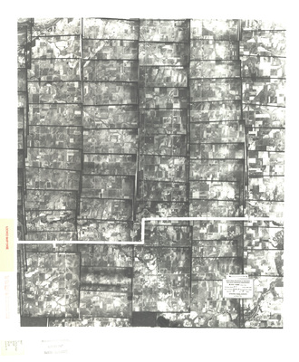
Photomosaic map of Black Hawk County, Iowa done for the U.S. Department of Agriculture Agricultural Adjustment Administration by Gatschet Aerial Surveys
Publication Date
1937
Publisher
United States Department of Agriculture, Agricultural Adjustment Administration
City of Publication
Washington, D.C.?
Object Description
1 JPEG file
Scale - Original
1:20,000
Rod Library Maps Subcollection
Iowa Maps
Physical Location
Special Collections & University Archives, Rod Library, University of Northern Iowa
Copyright
©1937 United States Department of Agriculture, Agricultural Adjustment Administration
Document Type
Map
Language
en
File Format
image/jpeg
Recommended Citation
United States. Agricultural Adjustment Administration, "Aerial survey [Black Hawk County] by Gatschet 1937 sheet 8" (1937). Rod Library Maps. 40.
https://scholarworks.uni.edu/rodmaps/40
Preview
Keywords
Black Hawk County (Iowa)--Remote-sensing images; Black Hawk County (Iowa)--Maps;

Comments
This is a part of a multi-image map. Click the links below to view the other parts:
Aerial survey [Black Hawk County] by Gatschet 1937 sheet 1
Aerial survey [Black Hawk County] by Gatschet 1937 sheet 2
Aerial survey [Black Hawk County] by Gatschet 1937 sheet 3
Aerial survey [Black Hawk County] by Gatschet 1937 sheet 4
Aerial survey [Black Hawk County] by Gatschet 1937 sheet 5
Aerial survey [Black Hawk County] by Gatschet 1937 sheet 6
Aerial survey [Black Hawk County] by Gatschet 1937 sheet 7
Aerial survey [Black Hawk County] by Gatschet 1937 sheet 9